TTCM
()
> Weather
—
Sunday,
April 28, 2024
—
W1
W2
W3
W4
239%
—
69°F
Washington, D.C., Weather
—
Sunrise: 6:13 (W1: 23%);
Solar Noon: 1:05 (W3: 53%);
Sunset: 7:58 (W5: 82%)
54
53
53
53
52
52
53
53
54
55
55
56
57
57
57
58
59
60
60
60
59
58
57
57
57
56
57
57
57
57
58
58
59
60
63
69
73
77
80
82
83
Last 72 Hours: Observations
—
Currently: 69°F
—
 —
Heavens-Above
—
Heavens-Above
70
69
68
66
65
65
64
65
68
72
80
84
85
87
89
90
92
90
89
87
83
79
77
75
73
72
71
70
68
67
66
66
70
73
76
80
83
85
86
87
87
86
84
82
79
77
75
73
...THE WASHINGTON NATIONAL DC CLIMATE SUMMARY FOR APRIL 27 2024...

WEATHER ITEM   OBSERVED TIME   RECORD YEAR NORMAL DEPARTURE LAST
                VALUE   (LST)  VALUE       VALUE  FROM      YEAR
                                                  NORMAL
TEMPERATURE (F)
 TODAY
  MAXIMUM         59   3:59 PM  95    1915  72    -13       72
  MINIMUM         52   5:41 AM  38    1876  52      0       52
                                      1892
                                      1933
  AVERAGE         56                        62     -6       62

PRECIPITATION (IN)
  TODAY            0.03          1.64 1954   0.12  -0.09     0.00
  MONTH TO DATE    2.06                      2.86  -0.80     1.48
  SINCE MAR 1      6.95                      6.36   0.59     3.08
  SINCE JAN 1     14.24                     11.84   2.40     6.81
Refresh
Tonight: Mostly clear, with a low around 64°. South wind 5 to 7 mph becoming calm after midnight.
Monday: Sunny, with a high near 92°. Southwest wind 3 to 7 mph.
Monday Night: Mostly clear, with a low around 65°. South wind around 6 mph.
Tuesday: A slight chance of showers between 2pm and 5pm, then a slight chance of showers and thunderstorms after 5pm. Mostly sunny, with a high near 89°. Southwest wind 6 to 8 mph. Chance of precipitation is 20%.
Tuesday Night: A chance of showers and thunderstorms before 11pm, then a chance of showers between 11pm and 2am, then a slight chance of showers and thunderstorms after 2am. Mostly cloudy, with a low around 66°. West wind 3 to 7 mph. Chance of precipitation is 40%.
Wednesday: A chance of showers, with thunderstorms also possible after 2pm. Mostly sunny, with a high near 82°. Chance of precipitation is 30%.
Wednesday Night: Partly cloudy, with a low around 59°.
Thursday: Mostly sunny, with a high near 80°.
Thursday Night: Partly cloudy, with a low around 58°.
Friday: Partly sunny, with a high near 82°.
Friday Night: A chance of showers. Mostly cloudy, with a low around 63°. Chance of precipitation is 30%.
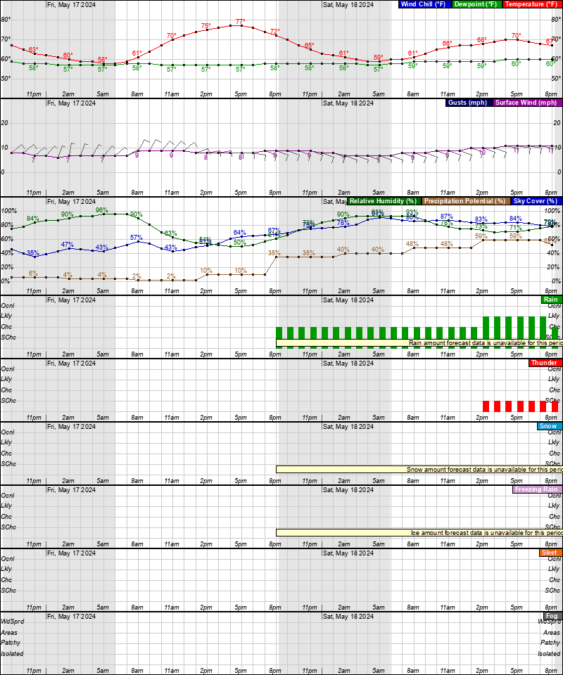
Saturday: A chance of showers. Mostly cloudy, with a high near 80°. Chance of precipitation is 50%.
Saturday Night: A chance of showers and thunderstorms. Mostly cloudy, with a low around 61°. Chance of precipitation is 40%.
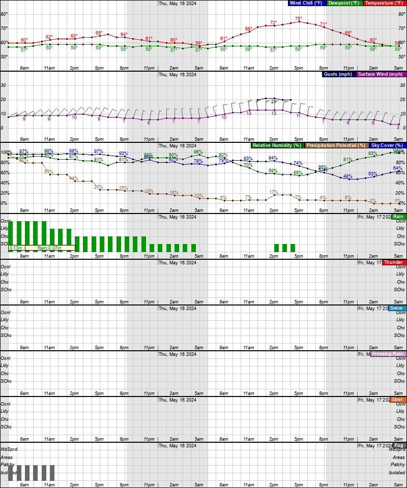
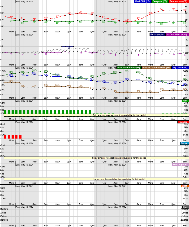
Sunday: A chance of showers. Partly sunny, with a high near 79°. Chance of precipitation is 30%.
Latest Forecast
Time and Date:
Today,
Sun-Moon,
Climate-Forecast
—
Light
ISS Sightings
—
Space Dashboard
Launch Calendars:
NASA,
KSC,
2019,
SFN,
SFI,
RLL,
SpaceX
Weather Prediction Center
•
Storm Prediction Center
•
Climate Prediction Center


Area Forecast Discussion
National Weather Service Baltimore MD/Washington DC
259 PM EDT Sun Apr 28 2024
.SYNOPSIS...
Very warm temperatures for late April are expected today through
Tuesday as high pressure sits off the Mid-Atlantic coast. Shower and
thunderstorm chances return Tuesday afternoon and again Wednesday as
a cold front crosses the region. High pressure briefly returns
Thursday before another front arrives late week and into the weekend
with additional afternoon showers and thunderstorms.
.NEAR TERM /UNTIL 7 AM MONDAY MORNING/...
Despite the slow erosion of this morning`s shallow inversion,
temperatures have warmed quite nicely under sunny to mostly
sunny skies. It`s a tease to Summer with temperatures running 20
to 30 degrees warmer from this time yesterday. Strong upper
level ridging combined with surface high pressure off the
coastal Carolinas are responsible for the quick change in
weather conditions. With the surface high offshore, an ample
supply of south to southwesterly flow will boost temperatures
well into the low to mid 80s across much of the region. Mountain
locations and areas right near the water will see highs in the
70s. Dry conditions will prevail with building heights although
an isolated shower or thunderstorm cannot be ruled out over the
higher peaks of the Potomac/Allegheny Highlands region. This
activity will be short lived given the lack of shear, lower
dewpoint/humidity values, and forcing across the region.
Skies will remain mostly clear to partly cloudy tonight with areas
of patchy dense fog in particularly over the river valleys along and
west of the Blue Ridge. Expect a mild night with lows in the upper
50s and low to mid 60s areawide.
.SHORT TERM /6 AM MONDAY MORNING THROUGH TUESDAY NIGHT/...
The strong upper level ridge continues to strengthen Monday as
surface high pressure drifts further off the southeast U.S coast.
This will yield a continuation of dry conditions and perhaps the
first 90 degree day of the year in many locations across the region.
Afternoon highs will reach into the mid to upper 80s for most with
lower 90s along the I-95 corridor south into the central VA
Piedmont. An isolated thunderstorm cannot be ruled out over the
mountains with chances less than 20 percent given a capping
inversion overhead. Mild conditions will continue Monday night with
lows remaining mild in the low to mid 60s.
Changes look to arrive Tuesday as the ridge begins to buckle. An
upper level trough and associated cold front look to push in from
the Great Lakes and Ohio River Valley Tuesday afternoon and evening
bringing renewed chances for showers and thunderstorms. A few of
these storms could be strong to severe although the chance for
widespread severe weather appears limited. This is due in part to
weak 0-6 km deep layer shear at 30 kts or less and lower dewpoint
values in the upper 50s and lows 60s. SPC currently keeps the area
in general thunder while the CSU learning probabilities
highlight areas east of the Blue Ridge for 15-30 percent
probabilities for a marginal risk of severe weather. With all
that said, any storms that do develop will be capable of
producing frequent lightning gusty winds, and locally heavy
rainfall (PWATS running 1-1.5"). High temperatures Tuesday will
push back into the mid to upper 80s with 70s over the
mountains/near the bay.
Shower and thunderstorm activity will gradually diminish in the
wake of the front Tuesday evening into Tuesday night.
Temperatures will fall back into the upper 50s and low 60s with
the front sitting south and east of the region. Areas of patChy
dense fog are also possible especially in areas that do see the
rain.
.LONG TERM /WEDNESDAY THROUGH SUNDAY/...
The front will still be progressing south through the area Wednesday
while a shortwave trough aloft passes to the south. A chance of
showers and perhaps even thunderstorms will linger depending on the
timing of these features. While temperatures will trend downward,
they will still remain around 10 degrees above normal, in the upper
70s and lower 80s. High pressure will be building southward from New
England Wednesday night with slightly cooler lows in the 50s.
Upper level ridging will build over the area Thursday, promoting dry
conditions. With the high progressing southward and low pressure
approaching the western Great Lakes, the warm sector will quickly be
established and temperatures will remain 5-10 degrees above normal.
The Great Lakes system will be on more of a northern trajectory as a
trough ejects through the northern Plains. As a result, chances for
rain have slowed for Friday, with a chance for a few showers and
storms mainly confined to the mountains. The trailing front will
eventually reach the area Saturday or Saturday night. The highest
chance for showers will be during this period. While thunderstorms
will be possible, instability will likely be fairly limited.
There remains enough ensemble spread in frontal/trough timing that a
chance for showers lingers into Sunday. Even if we are solidly
by that time, temperatures are forecast to remain above normal
as a zonal flow is in place aloft.
Latest Discussion
- Climate — Genesis 8:22
- While the earth remains, seedtime and harvest, cold and heat, winter and summer, and day and night shall not cease.
- Sea Level — Job 38:8-11
- Who shut in the sea with doors, when it burst forth and issued from the womb; when I made the clouds its garment, and thick darkness its swaddling band; when I fixed My limit for it, and set bars and doors; when I said, ‘This far you may come, but no farther, and here your proud waves must stop!’
About