TTCM
()
> Weather
—
Sunday,
May 5, 2024
—
W1
W2
W3
W4
W5
—
55°F
Washington, D.C., Weather
—
Sunrise: 6:06 (W1: 20%);
Solar Noon: 1:05 (W3: 52%);
Sunset: 8:04 (W5: 85%)
60
60
60
59
58
57
57
57
56
57
57
57
57
58
58
59
60
63
69
73
77
80
82
83
Last 72 Hours: Observations
—
Currently: 55°F
—
 —
Heavens-Above
—
Heavens-Above
55
55
55
55
55
55
56
56
58
59
61
63
64
66
67
68
69
69
69
68
67
66
66
65
65
65
65
65
65
65
65
66
66
68
71
73
75
77
78
79
79
79
78
77
75
73
71
68
...THE WASHINGTON NATIONAL DC CLIMATE SUMMARY FOR MAY 4 2024...

WEATHER ITEM   OBSERVED TIME   RECORD YEAR NORMAL DEPARTURE LAST
                VALUE   (LST)  VALUE       VALUE  FROM      YEAR
                                                  NORMAL
TEMPERATURE (F)
 TODAY
  MAXIMUM         56   1:39 PM  93    1928  74    -18       64
  MINIMUM         53   5:34 AM  39    1986  54     -1       47
  AVERAGE         55                        64     -9       56

PRECIPITATION (IN)
  TODAY            0.82          1.77 1922   0.13   0.69     0.00
  MONTH TO DATE    0.82                      0.50   0.32     0.01
  SINCE MAR 1      7.77                      7.21   0.56     5.16
  SINCE JAN 1     15.06                     12.69   2.37     8.89
Refresh
Hazardous Weather Outlook
Coastal Flood Advisory
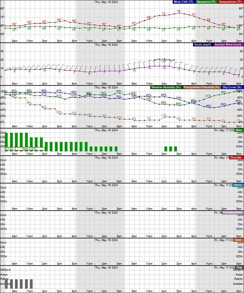
Tonight: Areas of drizzle with a chance of rain before 2am, then rain with areas of drizzle, mainly after 2am. Patchy fog before 5am. Low around 54°. East wind around 9 mph. Chance of precipitation is 80%. New precipitation amounts between a tenth and quarter of an inch possible.
Sunday: Rain with areas of drizzle before noon, then showers likely, mainly between noon and 4pm. Patchy fog before 4pm. High near 71°. South wind 6 to 8 mph. Chance of precipitation is 90%. New precipitation amounts between a tenth and quarter of an inch possible.
Sunday Night: Showers and thunderstorms likely before 2am, then a slight chance of showers. Patchy fog between 7pm and 5am. Otherwise, mostly cloudy, with a low around 64°. Southeast wind 5 to 7 mph. Chance of precipitation is 60%. New rainfall amounts of less than a tenth of an inch, except higher amounts possible in thunderstorms.
Monday: A slight chance of showers, then a chance of showers and thunderstorms after 2pm. Patchy fog between 8am and 10am. Otherwise, mostly cloudy, with a high near 80°. Southwest wind around 5 mph. Chance of precipitation is 50%.
Monday Night: A chance of showers and thunderstorms before 8pm, then showers likely and possibly a thunderstorm between 8pm and 2am, then a chance of showers and thunderstorms after 2am. Mostly cloudy, with a low around 65°. Light and variable wind. Chance of precipitation is 60%.
Tuesday: A chance of showers and thunderstorms before 8am, then a chance of showers between 8am and 11am, then a chance of showers and thunderstorms after 11am. Partly sunny, with a high near 80°. Chance of precipitation is 50%.
Tuesday Night: A chance of thunderstorms before 8pm. Mostly cloudy, with a low around 66°. Chance of precipitation is 30%.
Wednesday: A chance of showers and thunderstorms after 2pm. Partly sunny, with a high near 87°. Chance of precipitation is 30%.
Wednesday Night: A chance of showers and thunderstorms. Mostly cloudy, with a low around 66°. Chance of precipitation is 50%.
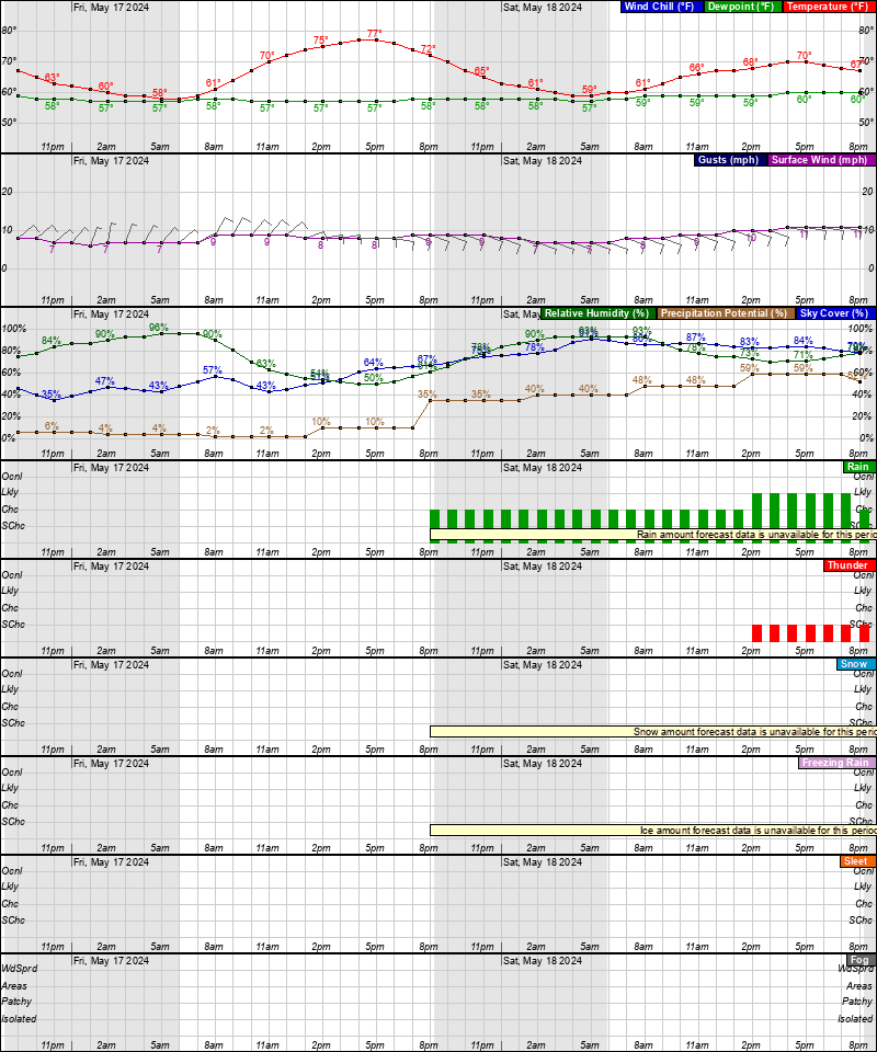
Thursday: A chance of showers, then showers likely and possibly a thunderstorm after 2pm. Mostly cloudy, with a high near 84°. Chance of precipitation is 70%.
Thursday Night: Showers and thunderstorms likely. Partly cloudy, with a low around 63°. Chance of precipitation is 60%.
Friday: Showers likely. Partly sunny, with a high near 76°. Chance of precipitation is 60%.
Friday Night: Showers likely. Partly cloudy, with a low around 56°. Chance of precipitation is 60%.
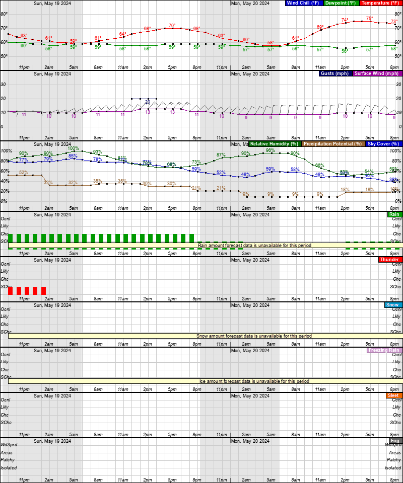
Saturday: A chance of showers. Mostly sunny, with a high near 71°. Chance of precipitation is 30%.
Baltimore/Washington Forecast Office
Latest Forecast
Time and Date:
Today,
Sun-Moon,
Climate-Forecast
—
Light
ISS Sightings
—
Space Dashboard
Launch Calendars:
NASA,
KSC,
2019,
SFN,
SFI,
RLL,
SpaceX
Weather Prediction Center
•
Storm Prediction Center
•
Climate Prediction Center


Discussion updates at 4 AM ET
Area Forecast Discussion
National Weather Service Baltimore MD/Washington DC
800 PM EDT Sat May 4 2024
.SYNOPSIS...
A stalled frontal boundary will remain draped to the south of
the forecast area through tonight before returning north as a
warm front late this weekend. This system will bring on and off
showers and possible thunderstorms. A secondary cold front will
move through the area on Monday before lifting northward as a
warm front on Tuesday. This boundary eventually stalls to the
north by the middle of the week. This will bring a prolonged
period of unsettled weather through much of the week.
.NEAR TERM /UNTIL 6 AM SUNDAY MORNING/...
The Mid-Atlantic remains firmly in the grasp of a CAD wedge.
Shortwave energy lifting out of the Tennessee Valley will carry
a more organized batch of showers through the region overnight
(seen on regional mosaic imagery near the VA/NC border east of
the Blue Ridge as of 8 PM). Another quarter to half inch of rain
is possible with this next batch, locally a bit higher in the
Blue Ridge Mountains or in areas that receive repeated heavier
downpours. Forecast low temperatures stay fairly close to the
readings reported right now. Widespread low to mid 50s are
likely with a few upper 40s possible across northeastern
Maryland. Easterly winds persist which helps maintain a thick
area of marine stratus clouds.
.SHORT TERM /6 AM SUNDAY MORNING THROUGH MONDAY NIGHT/...
Expect warmer temperatures for Sunday as the mentioned boundary
returns northeastward as a warm front. Model guidance is
notoriously too quick in lifting these boundaries poleward.
Thus, there may be some north-south temperature gradient over
the forecast area where locations near the Mason-Dixon Line
stay much cooler. The current forecast package calls for
mid/upper 60s across northern Maryland and the local mountains.
Meanwhile, low/mid 70s are more commonplace elsewhere. There may
be some breaks in the cloud cover as winds shift from easterly
to south-southeasterly. Where these breaks occur will dictate
where any convective threat resides. For now, have placed a bulk
of the area with a slight chance for afternoon/evening
thunderstorms. Gradually taper off this threat into the
overnight hours as any instability is lost after dark. Some
patchy fog is possible given recent rainfall, decreasing winds,
and a moist boundary layer. Nighttime lows remain mild,
generally staying in the upper 50s to mid 60s.
An approaching cold front ends up on the door step of the local
area on Monday. This system eventually stalls in the vicinity
by late Monday night. Its close proximity to the area will
maintain shower and thunderstorm chances to start off the work
week. However, temperatures should warm up rather markedly with
the Mid-Atlantic fully into the warm sector. Forecast highs are
in the upper 70s to low 80s, locally in the upper 60s to low 70s
across mountain locales. Expect yet another mild night with
lows in the upper 50s to mid 60s. Compared to typical early May
nights, this is around 10 to 15 degrees above normal.
.LONG TERM /TUESDAY THROUGH SATURDAY/...
The unsettled and active weather pattern is likely to continue
through the rest of the week, then possibly dry out next weekend.
Aloft, nearly zonal flow continues as several shortwave troughs
traverse the region. At the surface, a stalled frontal boundary is
likely to be located north of the area, over central to southern PA,
through mid week as a few waves of low pressure move across it.
Moisture and instability are likely to be plentiful each day,
leading to scattered to widespread showers and thunderstorms each
afternoon. Most of the daytime activity dissipates by late evening,
though a few showers could linger through the overnight. There is
some model agreement for drier conditions next weekend as surface
high pressure builds into the region.
The most active period looks to be Wednesday night through Thursday
evening. This is when the strongest mid-level trough of the week and
an associated surface cold front cross the Mid-Atlantic. Our area
should be squarely in the warm sector, with plenty of instability
and moisture available (PWATs over 1.5-1.6" possible). Some strong
to severe storms are possible Thursday as a line of storms develop
along the passing cold front. The better chances for severe storms
look to be east of the Blue Ridge where ample instability and shear
(model soundings indicate 40-50kt of bulk shear) are more likely to
be present. The biggest question mark is whether early morning cloud
cover dissipates in time to allow for better instability to develop.
Moderate to heavy rainfall is also possible areawide, which could
lead to some instances of flooding (though it is also highly
dependent on how much rain falls in the prior days).
Temperatures continue to warm through mid week as highs in the low
80s Tuesday reach the mid to upper 80s Wednesday and Thursday.
Slightly cooler temperatures in the 70s behind the cold front Friday
into Saturday. Very mild overnight lows in the 60s, then cooling a
bit to the 50s Friday night.
Latest Discussion
- Climate — Genesis 8:22
- While the earth remains, seedtime and harvest, cold and heat, winter and summer, and day and night shall not cease.
- Sea Level — Job 38:8-11
- Who shut in the sea with doors, when it burst forth and issued from the womb; when I made the clouds its garment, and thick darkness its swaddling band; when I fixed My limit for it, and set bars and doors; when I said, ‘This far you may come, but no farther, and here your proud waves must stop!’
About